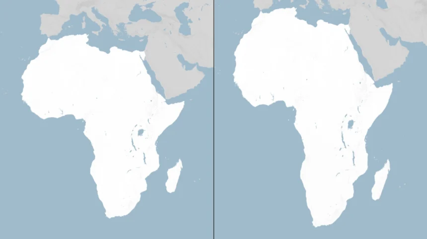
On Friday, 4 September 2026, the UN General Assembly delivered a striking symbolic correction to a centuries-old visual bias by endorsing a resolution urging the world to move away from the Mercator projection and adopt equal-area maps that show Africa’s true relative size.
The new policy doesn’t create new political boundaries or ban any map, but it calls into question the way generations have viewed the world—and, therefore, how they assess the value of different parts of the world. The policy, entitled “Correct the Map,” was adopted in a vote of 164 in favor, 1 against (United States), and 6 abstentions, highlighting both the level of international consensus and the geopolitical fault lines surrounding narrative, memory, and representation. In essence, it’s a tale of power and perspective. Maps are not neutral; they are arguments in pixels and paper. In making equal-area projection maps the standard—the Equal Earth map is one example, created in 2018—the UN is asking the governments, schools, media outlets, and technology companies to address a distortion that has long devalued equatorial areas, particularly Africa, since the 16th century.
As Robert Dussey, Togo’s foreign minister and a lead voice behind the African Group’s initiative, put it:
“Maps shape our understanding of the world. They guide education, nourish the imagination, and influence collective perceptions.”
The Mercator legacy: navigation’s triumph, geography’s compromise
In order to comprehend the gravity of the issue, it is necessary to look back at 1569, when Flemish cartographer Gerardus Mercator released a world map specifically for the use of sailors. It offered perfect direction; rhumb lines were straight lines, therefore making the Mercator projection an extremely useful map for navigation.
But such an advantage meant distortion of the map: it stretched out regions away from the equator and made the regions close to the equator smaller. Thus, Greenland appears to be about the same size as Africa, although in reality the latter region is 14 times bigger. Northern Europe and North America seem to be too big compared to their actual sizes as well. For years, such a distortion affected the perception of the globe in classrooms, news media and everywhere else. The Mercator map became a universal “world map” or a seemingly objective depiction of the Earth, which is actually a navigation map used for other purposes. This default has been misleading geographers for years; hence, the intention of the UN resolution is to change that misleading where relative size plays a role.
Equal Earth and the case for area-accurate maps
The resolution does not mandate a single replacement. Instead, it promotes the use of equal-area projections—maps that preserve relative land area, even if they must compromise on shape—when the goal is to convey how big countries and continents truly are. Among these, the Equal Earth projection, created in 2018 by cartographers Tom Patterson, Bernhard Jenny and Bojan Šavri?, has become the campaign’s poster child. Equal Earth balances visual familiarity with area accuracy, making it suitable for atlases, classroom walls, media graphics and UN publications where comparative size is central.
No flat map can perfectly render a spherical Earth; every projection distorts something. The point of the resolution is not cartographic purity but contextual honesty: if the purpose is to show how large Africa is relative to Europe or how India compares to Greenland, an equal-area map is the truthful choice. As the text makes clear, this is about teaching the limitations of any flat map and ensuring that visual representations do not inadvertently reinforce outdated hierarchies of significance.
The African Group’s framing: cognitive justice and memorial reparation
“Correct the Map” has been sponsored by Togo and supported by the African Union, and according to its supporters, this resolution aims at rectifying the wrong knowledge representation in visual form. According to the African diplomats, it is the Mercator projection that has reduced the image of Africa, thus contributing to the discourse of marginalization. From the point of view of African diplomats, correcting the map is a kind of memorial reparation that deals with symbolic injury present in the tools of everyday knowledge transfer. Such a perspective helps explain why the resolution gained so much popularity beyond cartographic practices. For some supporters, it means that visual representations also become part of the postcolonial project.
Dussey captured this when he said,
“A fair map does not change the geography of the world, it changes how we see the world.”
That line, repeated in corridors and press briefings, distilled the campaign’s core claim: geography is fixed; perception is not.
The United States’ solitary “no”: ideology, reparations and institutional credibility
The lone dissenting vote came from the United States, which characterized the resolution as part of a “radical ideological project” and warned that such initiatives are
“barnacles on our work here and the reason this institution is losing its credibility.”
Washington’s objection focused less on cartography and more on the resolution’s language around reparations and cognitive justice, which U.S. officials argued distracts from core UN priorities and injects contentious historical narratives into technical domains.
The U.S. stance underscores a broader debate about the UN’s role: is it a forum for correcting historical injustices through symbolic acts, or should it confine itself to narrowly defined operational mandates? For Washington, this resolution crossed into the former. For the African Group and its allies, the symbolic is substantive; misrepresentation in maps is not a harmless quirk but a persistent signal that shapes policy, investment and public opinion. The abstentions—Estonia, Georgia, Lithuania, Moldova, Serbia and Ukraine—hint at another layer of concern: the fear that reimagining maps could open disputes over borders and sovereignty, even if the text explicitly disclaims that intent.
Ukraine’s caution and the EU’s boundary-setting
It is worth noting that the decision of Ukraine to abstain was prompted by the specific concern regarding the possible misrepresentation of occupied areas on some equal-area maps, such as the Equal Earth ones. Kyiv agreed with the idea of correcting the distortion of Africa, yet it expressed concerns that such an approach could lead to the opening of a “Pandora’s box” with the borders. Despite supporting the resolution, the European Union managed to clarify the scope of its application by establishing clear parameters. According to EU officials, the resolution refers only to the sizes of the landmasses but not to their sovereignty or borders recognized at the international level.
Moreover, the EU made it clear that it does not imply any endorsement of particular maps, which can be found on the Equal Earth website. This is important because it is necessary to keep in mind that despite the growing political willingness to make the maps more area-accurate, states will make sure to monitor the limits to avoid any unintended spill-over into the border issue.
France’s pivot and the ripple effect in media and education
Among the most consequential endorsements came from France, which announced plans to abandon the Mercator projection for its world maps, aligning with the African Union’s push. The practical effect will be visible: France and other high-latitude countries will appear smaller relative to equatorial regions, bringing visual proportion closer to geographic reality. This shift is likely to ripple through French textbooks, official publications and media graphics, setting a precedent that other European and Global North countries may follow.
For journalists and educators, the implication is straightforward: when the story is about comparative size—population density, resource endowment, market scale—an equal-area map is now the defensible default. Newsrooms that continue to use Mercator for such stories will face a higher burden to justify why a known distorting projection is preferable. In classrooms, teachers will be encouraged to explain why no flat map is perfect and why different projections serve different purposes. The goal is not to erase Mercator but to contextualize it.
What the resolution does—and does not—do
A clear scope definition is necessary to prevent over-interpretation of the text. The resolution calls for the use of equal-area projections to show relative land area by governments, international organizations, schools, media, and technology firms. It asks for curricula that contain information about the limitations of flat maps and the need for various projections. It does not call for a prohibition of the Mercator projection, does not suggest the replacement of the Mercator projection with one map projection throughout the world, and does not affect borders, territorial claims, or legal boundaries. Its scope is limited to showing relative areas, not territorial claims.
This reasonable approach explains why there is such a broad coalition in favor of the text. Nations that would oppose mandatory rules could support a non-binding suggestion, especially when accompanied by clear statements about borders. There is also room for recommendations specific to sectors – navigation and certain technical industries could use Mercator where its characteristics are critical, whereas education, media, and general mapping would move towards equal-area projections.
The broader stakes: perception, policy and the politics of scale
Why does a map matter? Because perception drives policy. Investors, voters and officials form intuitions about regions partly through the images they consume. A map that visually shrinks Africa can, over time, contribute to underestimating its demographic heft, economic potential and strategic relevance. Conversely, a map that shows Africa’s true scale can recalibrate those intuitions, making it harder to dismiss the continent as peripheral. This is not about inflating Africa’s importance; it is about aligning visual cues with geographic facts.
The African Union’s post-vote statement captured the ambition: the resolution promotes equal-area maps
“across classrooms, media, and international institutions, ensuring the world map finally reflects Africa’s true scale, weight, and place in the world.”
That language—scale, weight, place—signals a desire to correct not just area but status. In an era where the Global South seeks a larger voice in climate finance, trade rules and security architectures, the map becomes a metaphor for representation itself.
Implementation realities: classrooms, newsrooms and tech platforms
All of the above will come down to the details. Ministries of Education will have to update their atlases and textbooks while balancing costs with curriculum requirements. Media outlets will have to change their style guide to dictate where equal-area maps are needed and where other projections may suffice. Internet platforms, which shape billions of users’ views through their default map settings, will have to provide users with an area-accurate option for thematic layers or educational material.
It doesn’t happen quickly and immediately, but the UN resolution gives these advocates an anchor to pull on within these organizations. There will be resistance, including from those who see the new standard as a political statement or from cartographic traditionalists who claim that all projections distort information and that Mercator projection provides an intuitive way to see the world. But at the same time, the resolution’s focus on the context—
“Use equal-area maps when the relative sizes of areas matter”
—provides an opportunity to move forward.
A century-old default, finally contested
It is important to note that it continued to be used because it proved itself useful in navigation and was embedded into culture, but it was far from being the most accurate projection for general purposes. Entrenchment does not equate to inevitability. By having 164 nations supporting the change towards more area-based projections, the United Nations made it known that the grammar of global politics should speak in the language of the 21st century, not of the 16th century. It is true that the US is standing alone with its “no” vote.